Site: Gorai Jetty
We were divided into groups and as a group our very first objective was to visit the site, observe patterns of people, vehicular movement or any other intersting activities we see and make detailed plan and sections of the sites.
_page-0001_edited.jpg)
_page-0001.jpg)
Next we moved on to making diagrams based on our observations.

This site context diagram maps Gorai Jetty’s surroundings—shops (blue) and hotels (red) cluster near the entrance, residential blocks (grey) spread nearby, while the jetty projects into water (blue) bordered by forest (green), framing potential zones for new programs and visitor flow.

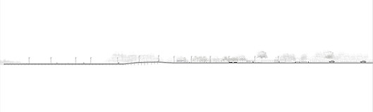
This plan shows site’s built form with three key annotations:
A – Partial roof covering sections of the jetty for shade,
B – Railings along edges for safety
C – Street lights for nighttime visibility.
The green zone represents adjacent land, while the blue area shows the waterfront’s edge, revealing where built elements meet open site potential.

This is a density diagram visualizing crowd flow at Gorai Jetty, where larger circles mark high-priority activity zones, medium circles indicate moderate use, and smaller circles show low-traffic areas,guiding spatial planning and program placement.

This section shows height changes and spacing along the jetty, revealing where people naturally slow, gather, or flow. These patterns guide program placement to align with crowd movement.
The next stage was to identify our place of intervention. This was determined by analyzing the site’s activities and the dynamic flow of movement.

I mapped crowd movement vectors, extending them into horizontals and verticals to create a spatial grid. I overlaid density diagrams showing high and low-traffic zones as circles, then extended the verticals from their centers to locate intersections. These points generated the organic curves that define the plan. I also studied vertical-distance variations along the jetty, noting where people naturally slow down or gather. Together, the vector mapping, density analysis, and elevation changes directed the placement of each program, ensuring the space responds directly to how the site is used.
My waiting space is a sea-view café that I’ve designed as a calm halt for people moving along the jetty. It begins with a portico entrance that subtly diverts visitors from the jetty and guides them up the stairs.